Latest Information
It's August 2021 and I haven't updated anything. There has have been a few developments new road works etc but the asbestos tailing dump remains the same and is expected to remain untouched but slowly eroding for some time yet.
September 22nd 2016
Since I last updated this page not a lot has happened in regard to the cleaning up of the Woodsreef Asbestos Mine site. Firstly continuing on from the last post on the 23rd April 2015. The meetings with Andrew Ellis and Brendon Barrett were indeed a waste of time and it was just another DRE box ticking exercise to say they had listed to the communities concerns. Which is true I guess. They did listen to the communities concerns. To bad that's all they did.
I resigned from being a member of the WCAG on 20th October 2015 as it was a total waste of time and effort dealing with DRE and the Woodsreef Taskforce. I also had other commitments which were more worthy of my attention. The WCAG was wound up a couple of weeks later due to the project coming to an end. Yes the project ended on time and on budget around October 2015. Despite all the lies and a general lack of respect from a number of people who the Advisory Group had to work with, including Minister Anthony Roberts and his staff that seem to have a literacy problem. I am quite happy with the end result. We have recently has quite a lot of rain but no really heavy downpours. However, I will still be interested to see how much asbestos laden water is flowing into Ironbark creek adjacent to the asbestos mine. Lots more needs to be done as there is still 24 000 000 yes that is correct , 24 million tonnes of asbestos tailings eroding away slowly making it's way into local rivers and streams, perhaps all the way downstream to Split Rock Dam.
April 23rd 2015
A very surprising letter was published in the Barraba Gazette on 8th April. The letter was from Kylie Hargreaves, Deputy Secretary Resources and Energy. A number of claims put forward by Ms Hargreaves in her letter can only be diplomatically described as incorrect. The letter refutes most of the claims put forward by members of the Woodsreef Community Advisory Group. What was perhaps more surprising than Ms Hargreaves misleading letter was the fact that it was published just three working days before community members of the WCAG were to meet with Andrew Ellis from the DRE Community Liaison Team and his manager Brendon Barrett. The task set for Mr Ellis and Barrett was gather information and concerns from community members of WCAG and report back to the head of the department, none other then Kylie Hargreaves. This leads me to the conclusion that the whole meeting with Mr Ellis and Barrett was a waste of time and was possibly just another DRE box ticking exercise. The WCAG community members have asked for an apology from Kylie Hargreaves. If no apology is ensuing then I guess the meeting with Mr Ellis and Barrett was indeed a waste of time as I expect. Click the link to read
Kylie Hargreaves letter to the Gazette. Click the link to read Danny Ballard's Response as published in the Barraba Gazette.
April 17th 2015
I am still waiting for answers to most of my questions posted on April 7th. The Woodsreef Community Advisory group has been vigorously pursuing answers for a number of questions raised after the demolition of the Mill building at Woodsreef but still has not been given adequate answers to their questions. The question I raised about why was the building was able to be demolished with several tonnes of asbestos sheeting still attached, has been answered to some degree. The project manager has informed me that they had gained approval for an exemption from WorkCover to leave the sheeting on while the building was demolished. This has been confirmed by WorkCover. WorkCover tells me that it would have been more dangerous to remove the asbestos sheeting before demolition, then it would be to simply blow the whole thing up with asbestos attached, my words, but that was the gist of the conversation. Regulation 447-457 states "ensure that asbestos that is likely to be disturbed is identified and, so far as reasonably practical, removed" I believe it could have been removed safely and that this part of the regulation has been misconstrued to suit the needs of the Woodsreef Taskforce and to protect their project budget. This part of the regulation was not written for this scenario. The Woodsreef Taskforce my had complied with the regulations but have not worked within the spirit of the regulations.
I am still waiting for answers to most of my questions posted on April 7th. The Woodsreef Community Advisory group has been vigorously pursuing answers for a number of questions raised after the demolition of the Mill building at Woodsreef but still has not been given adequate answers to their questions. The question I raised about why was the building was able to be demolished with several tonnes of asbestos sheeting still attached, has been answered to some degree. The project manager has informed me that they had gained approval for an exemption from WorkCover to leave the sheeting on while the building was demolished. This has been confirmed by WorkCover. WorkCover tells me that it would have been more dangerous to remove the asbestos sheeting before demolition, then it would be to simply blow the whole thing up with asbestos attached, my words, but that was the gist of the conversation. Regulation 447-457 states "ensure that asbestos that is likely to be disturbed is identified and, so far as reasonably practical, removed" I believe it could have been removed safely and that this part of the regulation has been misconstrued to suit the needs of the Woodsreef Taskforce and to protect their project budget. This part of the regulation was not written for this scenario. The Woodsreef Taskforce my had complied with the regulations but have not worked within the spirit of the regulations.
7th April 2015
It has been 2 months since asbestos clad mill building was brought crashing down in a cloud of dust using explosives. The Woodsreef Community Advisory Group and the community has raised a number of concerns in regard to how this building was demolished with several tonnes of asbestos sheeting contain blue and brown asbestos still attached to the building in contraventions of "How to manage and control Asbestos in the Workplace" Code of practice (regulation 447-457) "How to safely remove Asbestos" Code of practice and the "Demolition Work Code of practice" (the less toxic white asbestos was mined at Woodsreef). The members of the Woodsreef Community Advisory Group who are meant to be a conduit for information to flow back and forth from the Woodsreef Taskforce to the community were told that there would be no implosion type demolition at all and the building would be dismantled using hydraulic shears as per my post on the 29th October below. We were also told no explosives would be used. Initial enquiries to "Trade and Investment" were met with the response that no explosives were used. Subsequent enquires then led to the story that yes, explosives were used but they were only small charges and there wasn't very much dust at all. The picture below captured by a visitor to a neighbouring property tells a very different story. The height of the hills behind the dust cloud are 140 to 160 metres above "The Mine" road. I estimate the height of the dust cloud to be at 200 metres high and 500 metres wide. Please read on below the image.
It has been 2 months since asbestos clad mill building was brought crashing down in a cloud of dust using explosives. The Woodsreef Community Advisory Group and the community has raised a number of concerns in regard to how this building was demolished with several tonnes of asbestos sheeting contain blue and brown asbestos still attached to the building in contraventions of "How to manage and control Asbestos in the Workplace" Code of practice (regulation 447-457) "How to safely remove Asbestos" Code of practice and the "Demolition Work Code of practice" (the less toxic white asbestos was mined at Woodsreef). The members of the Woodsreef Community Advisory Group who are meant to be a conduit for information to flow back and forth from the Woodsreef Taskforce to the community were told that there would be no implosion type demolition at all and the building would be dismantled using hydraulic shears as per my post on the 29th October below. We were also told no explosives would be used. Initial enquiries to "Trade and Investment" were met with the response that no explosives were used. Subsequent enquires then led to the story that yes, explosives were used but they were only small charges and there wasn't very much dust at all. The picture below captured by a visitor to a neighbouring property tells a very different story. The height of the hills behind the dust cloud are 140 to 160 metres above "The Mine" road. I estimate the height of the dust cloud to be at 200 metres high and 500 metres wide. Please read on below the image.
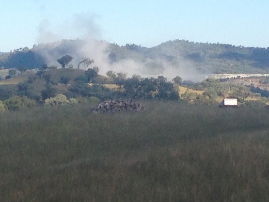
There are three residences within 2 km of the Mill building yet not one of them was notified of the pending explosion or the accompanying dust cloud. There is no doubt that some of the dust from this explosion would have settled on their property and on their homes. Trade and Investment have said that air monitoring results taken at the time of the explosion were negative for asbestos fibres. However given the string of misleading information emanating from DRE (Department of Resources and Energy) representatives, who would know what to believe? We previously had a site contaminated with Chrysotile, a less toxic form of asbestos. We now quite possibly have a site contaminated with the most toxic form of asbestos know to man, crocidolite and amosite thanks very much to the efforts of DRE and the NSW government. Unless of course they can prove otherwise by soil sampling after the demolition is complete. Below are a number of questions that, 2 months since the explosion I have not received adequate answers for from anyone.
* Why was the mill building imploded using explosives when the Woodsreef Community Advisory Group and the community were told this definitely would not be happening?
*If there had been a change of plan in regard to the demolition why wasn't the WCAG informed either by phone or email?
* Why was the asbestos sheeting left on the building before the explosion in contravention to the demolition code of practice?
*Why are trucks taking steel from the contaminated site and driving through Barraba, Manilla, Tamworth and beyond in open dump trucks bound for Newcastle when we were specifically told the steel would not be recycled ?
* Why were we told that NOTHING would leave the contaminated site and that ALL material including the steel would be buried on site when in fact several tonnes have left the site?
*If there had been a change of plan in regard to recycling the steel, why weren't the WCAG and community told either by phone or email?
* Why weren't local residents who live near the mine site told of the blast schedule and impending dust cloud especially since some of this dust would have settled on their residential buildings?
* Why has the Woodsreef Taskforce and NSW government felt it acceptable to further contaminate the Woodsreef mine site with a much deadlier form of asbestos in the form of both Amosite and Crocidolite?
Other questions have been raised in regard to the three photo's below. These photo's were not available on the webcam site but have miraculously appeared on T&I Woodsreef page. Have the webcam photos been edited so the public see only what T&I want them to see? Are there photos missing showing the rather incriminating dust cloud created by the explosion? The webcam photos that were available from the webcam site are below in my 8th February post.
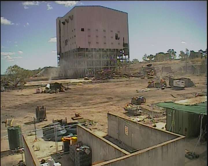
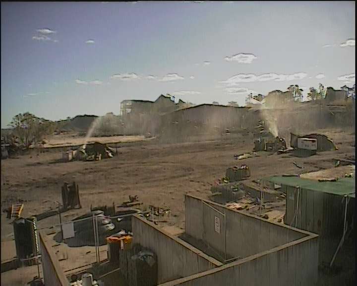
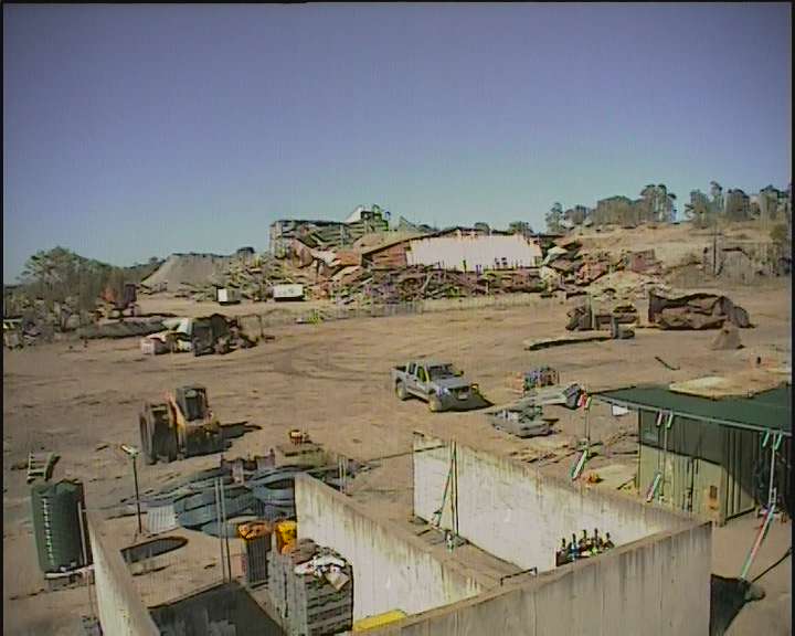
8th February 2015
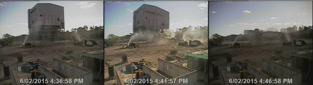
On Friday 6th February around 5.50 pm the 9 story tall Mill building at the Woodsreef mine site was finally demolished. It now lays as a heap of rumble on the ground waiting for removal to the onsite sealed containment cell. The photos below, taken from the onsite webcam show: Before, After and then in the light of Sunday morning.
|
|
|
5th February 2015
The Woodsreef Taskforce has had a couple of webcams installed on site so members of the public can see what is happening out there. The cameras came online in December 2014 but I have been a little slow (ok, more then a little slow) on getting the link posted on my website, partly due to slackness and partly due to the fact that when they were first installed it was like watching paint dry as nothing much was happening. Anyway here is the link, username and password.
- www.rmcam.com.au/login
- Username: Woodsreef
- Password: 1234
29th October 2014
The Woodsreef Community Advisory Group met at the Playhouse Hotel in Barraba for their October 20th scheduled meeting. Members of the Woodsreef Taskforce and representatives from the demolition contractor (Delta Group) were also in attendance. All WCAG members had questions relating to the release of the first round of air monitoring results which they believed would be available after some contractual issues had been sorted out with the contractor. The minutes from the June 23rd meeting state; "The chair explained the contractual issues and the delay in the release of the first round of air monitoring results and how these results are tied into the 1st Health Risk Assessment Report". However community members of WCAG have now been told the the results will not be available until the Health Risk Assessment has been fully completed. Despite protests by community members both government representatives from NSW Trade and Investment indicated that this subject was non negotiable and they were not comfortable in releasing an incomplete report.
The ecologist employed to monitor the Large Eared Pied Bats has given the all clear for works to commence as the buildings are currently bat free. Noise will be used to stop the bats returning whilst the demolition is in progress. Letters will be issue to people in the vicinity of the mine site to let them know what's happening on site.
Actual demolition is expected to commence in early November although this may not be evident at first due to a number of minor works needing to take place before major demolition of the Mill building can take place. Extremely powerful hydraulic shears that can cut through steel and concrete will be used to dismantle the building before all debris is appropriately buried on site in a containment cell. Water and Polyvinyl Acetate solution will be used to suppress dust and fibres while demolition works are in process. A web-cam is also being installed so members of the public can see what's happening on site during demolition works. Access to this camera should be available in the near future.
The October 20th meeting agenda a further information is available on the NSW Trade and Investment website.
http://www.resourcesandenergy.nsw.gov.au/miners-and-explorers/programs-and-initiatives/derelict/woodsreef-mine-major-rehabilitation-project
14th August 2014
The Letter of Award for the Woodsreef Mine Major Rehabilitation Project Demolition Works was issued to the contractor, Delta Pty Ltd, dated 13 August 2014 for the Contract Sum of $3,989,800.00.
The Contract has 4 milestones:
1. WorkCover Approvals - 6 weeks – 24 Sep 14
2. Planning activities and site establishment - 4 weeks – 22 Oct 14
3. All other works required to achieve completion other than Milestone 4 – 30 weeks – 3 Jun 15
4. Demobilisation from site – 2 weeks – 17 Jun 15
Unforeseen weather and other delays have not been calculated
4th August 2014
The Woodsreef Community Advisory group met again on 31st July for another update as the Woodsreef rehabilitation project begins to gain momentum. The main news at the meeting was the fact that the PER ( Public Environmental Review ) had been approved by the commonwealth government. A number of conditions have to be met during the project, however these are not expected to hamper progress of the demolition and corresponding clean up at the site. Demolition is expected to start September / October this year. The tender process has now closed and a tender has already been chosen. Details of the winning tender will be released towards the end of August.
A Hazard Identification Report is currently be critiqued. This report will identify the hazards on site and recommendations on how to avoid or mitigate any hazards. This report should also contain the official results of soil testing on site and adjacent areas which was done in 2013.
Air monitoring results from the testing done in late 2013 are still not available. Hopefully this data will be available in October.
Advisory group members also raised concerns about extra costs for transporting stock and fertilizer due to 'Mine Road' being closed. Concerns were also raised about mounting costs of local farming families having to service properties at either end of the 'Mine Road', now that the road has been closed costs are about triple what they were prior to the road closure. The cost in time is also considerable. The Advisory Group and local landholders are also very concerned about the ability of the RFS to effectively suppress any bushfire activity in the Woodsreef area due to restricted access due to the 'Mine Road closure'.
30th July 2014
The Woodsreef Community Advisory group met on the 24th June for an update on how things were proceeding at Woodsreef. The minutes of the meeting are available here. The information gained at this meeting as I understand it, is as follows. The State REF (review of environmental factors) has been approved but Commonwealth approval has not been granted yet. The main reason for the delay in the commonwealth approval is due to a land claim of the Woodsreef reserve / conservation area. This is not expected to impact on the works at all but necessitates some alterations to the conditions and legal framework before consent can be given by the commonwealth authorities. This is not expected to hold up the demolition and site works as approval is expected in the immediate future. Work is expected to commence in September 2014.
As part of the approval process the Woodsreef Taskforce / Department of Trade and Investment is responsible for the well being of all the pied eared bats in the Woodsreef locality for a period of 2 years after the commencement date of the works.
Tenders for the demolition works closed on 24th June.
Stage 1 of the drainage works started on Monday 16th June.
Results of background air monitoring that commenced earlier this year are expected to be available soon. Once demolition starts there will be 12 rounds of air monitoring done at 1 round every 12 day. Demolition may take up to 32 weeks to completed. Onsite air monitoring in the immediate area of the mill building will take place every 4 hours to meet occupational health and safely guidelines. I raised concerns about the first round of air monitoring. The mine road was open when this round was done. Therefore any positive results may be due to the ' Mine road ' being open and generating dust. The road is now closed but areas that may be deemed dangerous after the first round of testing maybe in fact safe. Air monitoring after the completion of the works will give the true results.
Other members of the Community Advisory Group raised concerns about properties being devalued due to the 'Mine road' being closed. Concerns were also raised about increased costs to landholders due to having to drive considerably longer distances to check on stock etc and increased costs for livestock and fertilizer transport. Concerns about access to town when Ironbark creek floods were also raised.
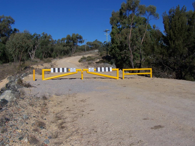
25 March 2014
The "Mine Road" was officially gazetted for closure and now large yellow gates have been installed to stop traffic using the "Mine Road" and driving past the tailings dump and mine site. Hopefully demolition work will be able to start before the end of the year. The photo below shows the new gates installed at the northern end of the "Mine Road".
10th December 2013
"Woodsreef Mine Major Rehabilitation Project" Draft Public Environmental Report is released at http://www.resources.nsw.gov.au/environment/derelict/woodsreef-mine-major-rehabilitation-project
5th December 2013
Deputy Premier Andrew Stoner renounces that "Mine Road" will close. Andrew Stoner's media release states that "the public health risks to keep the road open were far to high". Member for Tamworth Kevin Anderson said he was "disappointed at the decision but completely understood the reasons behind the closure."
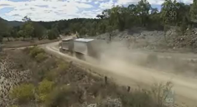
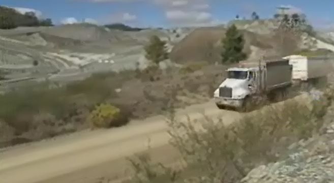
Comment. I believe that the road closure was inevitable. I have always believed that the only way forward was to have the road re-routed south of the mine site. However due to a number of contributing factors it quickly became apparent this was not going to happen. Some of the contributing factors include; cost, the possibility of encountering asbestos during construction of the re-routed road and the unwillingness of members of the Woodsreef Stakeholders Group to except any form of compromise other then to seal the road or leave exactly as is. Other suggestions that the upgrade of the Ironbark Creek bridge would help alleviate some of the access concerns during flooding were also dismissed by members of the Woodreef Stakeholders Group.The all or nothing position of the Woodsreef Stackholders Group has gotten them exactly that "NOTHING"!
The picture below shows a dump truck using the "Mine Road"
"Woodsreef Mine Major Rehabilitation Project" Draft Public Environmental Report is released at http://www.resources.nsw.gov.au/environment/derelict/woodsreef-mine-major-rehabilitation-project
5th December 2013
Deputy Premier Andrew Stoner renounces that "Mine Road" will close. Andrew Stoner's media release states that "the public health risks to keep the road open were far to high". Member for Tamworth Kevin Anderson said he was "disappointed at the decision but completely understood the reasons behind the closure."
Comment. I believe that the road closure was inevitable. I have always believed that the only way forward was to have the road re-routed south of the mine site. However due to a number of contributing factors it quickly became apparent this was not going to happen. Some of the contributing factors include; cost, the possibility of encountering asbestos during construction of the re-routed road and the unwillingness of members of the Woodsreef Stakeholders Group to except any form of compromise other then to seal the road or leave exactly as is. Other suggestions that the upgrade of the Ironbark Creek bridge would help alleviate some of the access concerns during flooding were also dismissed by members of the Woodreef Stakeholders Group.The all or nothing position of the Woodsreef Stackholders Group has gotten them exactly that "NOTHING"!
The picture below shows a dump truck using the "Mine Road"
|
|
26th November 2013
The Woodsreef Community Advisory Group (WCAG) met at the "Playhouse Hotel" in Barraba. The purpose of this meeting was to update members on how things were progressing and for a visit to some of the air monitoring sites. The visit to the air monitoring sites was greatly enhanced by the presence of SLR staff who have been contracted to do the air monitoring. Members were able to see first hand how the air monitoring process was done. SLR staff answered numerous questions and explained how the whole process was carried out. The state environmental process is still under way but is progressing. The Federal environmental process is also under way but is moving at a snails pace. At this point in time no one has any real idea when other works will proceed.
The Woodsreef Community Advisory Group (WCAG) met at the "Playhouse Hotel" in Barraba. The purpose of this meeting was to update members on how things were progressing and for a visit to some of the air monitoring sites. The visit to the air monitoring sites was greatly enhanced by the presence of SLR staff who have been contracted to do the air monitoring. Members were able to see first hand how the air monitoring process was done. SLR staff answered numerous questions and explained how the whole process was carried out. The state environmental process is still under way but is progressing. The Federal environmental process is also under way but is moving at a snails pace. At this point in time no one has any real idea when other works will proceed.
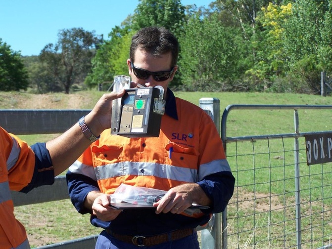
SLR staff explain how the air monitoring unit works.
5th September 2013 (Mine Road Scoping Study-available here)
A Public meeting was called by Kevin Anderson, member for Tamworth to discuss the findings of a scoping report into the re-routing of the "Mine Road". The meeting was held at the Playhouse Hotel in Barraba. The meeting was attended by Kevin Anderson MP, Mayor Col Murray, Councillor Phil Betts, Wayne Smith (Ministery of Health), Craig Lamberton (EPA), Alison Stone (Crown Lands) Viv Cadungog (SKM) Andrew Spinks (SKM) Scott Stanton (Crown Lands) along with other departmental staff who sat in the public gallery. The meeting was also attended by all three members of the WCAG and around 30 members of the public.
The report was actually finished in June 2013 but not released to the public until this meeting after being scrutinised by Andrew Stoner the deputy premier, according to Mr Anderson. The most common concern brought up at the meeting was about all weather access to town when Ironbark creek is in flood. Most people were very concerned that none of the proposed routes provided flood free access as no high level bridge was included in the plans on display. Currently flood free access is available by using the "Mine Road" and Pera-Linton road to get to the Fossickers Way.
There where a number of suggestions put forward by members of the public including flood proofing Avondale and Pera-Linton road, build a tunnel over the "Mine Road", build 2 high level bridges over Ironbark creek, a track with causeway for a new bypass and high level bridge over Ironbark creek and to simply seal the road and leave it open. Two individuals also contested that Chrysotile asbestos was perfectly safe and is of no danger to anyone. Professor Wayne Smith told the audience that Chrysotile asbestos is a Class 1 carcinogen as recognised by the World Health Organisation and absolutely definitely causes a wide variety of cancers. One of the same individuals also said that Ironbark reached a level of 7 metres above the normal water level in 1970/1971. The meeting finished with most, if not all believing the whole thing was a waste of time.
Comment : I don't believe pushing the Chrysotile isn't dangerous argument over and over again in the face of Health experts with decades of experience and damming evidence from around the world is helping the situation at all. It is simply making us look like a bunch of uneducated country hicks. That is not what I want because it is simply not true. Whether we believe Chrysotile asbestos is dangerous or not is up to the individual concerned but as I have said constantly going on an on about it is not helping the situation at all. Also treating others with contempt and over exaggerating river levels when data is available to clearly show it is false probably isn't doing us a lot of good either.
16th August 2013
The Community Advisory Group met with Kate Maddison, Woodsreef Project Manager and Scott Stanton from Crown Lands. The meeting was to update the group on proposed air monitoring sites. The group insisted that the Mine Road be included as one of the static or background monitoring sites and not solely as an active monitoring site as proposed by the consultant. The group also asked again that the sites used in the Dames and Moore report from 1997 also be used so monitoring results could be compared. Not much else was discussed except an explanation of where the REF (revue of environmental factors) was up to.
24th June 2013
The Woodsreef Community Advisory Group (WCAG) met with the the Woodsreef Taskforce in Barraba on the 24th June 2013. Most members of the Taskforce were in attendance as well as representatives of SLR consulting who have been engaged to do the air monitoring.
So far SLR has only done testing of soil samples. 46 samples weighing 4 to 8 kgs were taken and analysed from six different areas. The majority contained chrysotile asbestos. Six samples were also taken from the road. They all contained chrysotile asbestos. Modern air current simulations have been done by SLR to help them come up with the most likely places to find airborne asbestos. Paula McIver, David Witten and myself also had a few suggestions for air monitoring locations as well. SLR hope to do the Static air monitoring as soon as possible. The Active part on the testing will take place at a later date. Active monitoring requires SLR staff to do things that people do when visiting Woodsreef, like bushwalking, picnicking, camping, fishing while wearing a mask with filters to pick and airborne asbestos fibres. Tuff job but I guess someone has to do it.
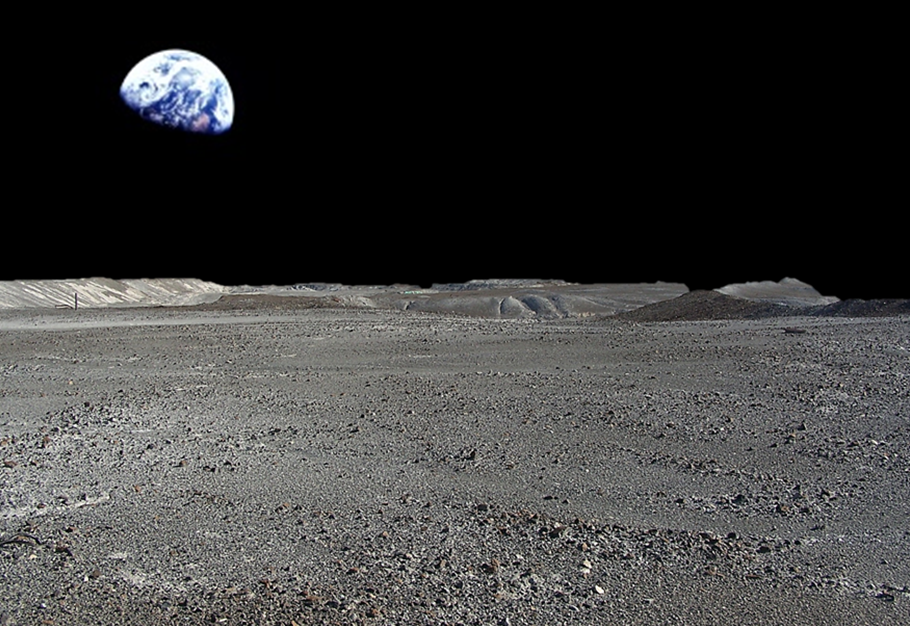
You may have also heard in the media that extra money has been allocated for Woodsreef in this years State budget. It is incorrect. The 4.5 million mentioned is simply the carry over from the year before.
The 2 photos below show why some people say the Woodsreef Tailings dump looks like a Moonscape.
A Public meeting was called by Kevin Anderson, member for Tamworth to discuss the findings of a scoping report into the re-routing of the "Mine Road". The meeting was held at the Playhouse Hotel in Barraba. The meeting was attended by Kevin Anderson MP, Mayor Col Murray, Councillor Phil Betts, Wayne Smith (Ministery of Health), Craig Lamberton (EPA), Alison Stone (Crown Lands) Viv Cadungog (SKM) Andrew Spinks (SKM) Scott Stanton (Crown Lands) along with other departmental staff who sat in the public gallery. The meeting was also attended by all three members of the WCAG and around 30 members of the public.
The report was actually finished in June 2013 but not released to the public until this meeting after being scrutinised by Andrew Stoner the deputy premier, according to Mr Anderson. The most common concern brought up at the meeting was about all weather access to town when Ironbark creek is in flood. Most people were very concerned that none of the proposed routes provided flood free access as no high level bridge was included in the plans on display. Currently flood free access is available by using the "Mine Road" and Pera-Linton road to get to the Fossickers Way.
There where a number of suggestions put forward by members of the public including flood proofing Avondale and Pera-Linton road, build a tunnel over the "Mine Road", build 2 high level bridges over Ironbark creek, a track with causeway for a new bypass and high level bridge over Ironbark creek and to simply seal the road and leave it open. Two individuals also contested that Chrysotile asbestos was perfectly safe and is of no danger to anyone. Professor Wayne Smith told the audience that Chrysotile asbestos is a Class 1 carcinogen as recognised by the World Health Organisation and absolutely definitely causes a wide variety of cancers. One of the same individuals also said that Ironbark reached a level of 7 metres above the normal water level in 1970/1971. The meeting finished with most, if not all believing the whole thing was a waste of time.
Comment : I don't believe pushing the Chrysotile isn't dangerous argument over and over again in the face of Health experts with decades of experience and damming evidence from around the world is helping the situation at all. It is simply making us look like a bunch of uneducated country hicks. That is not what I want because it is simply not true. Whether we believe Chrysotile asbestos is dangerous or not is up to the individual concerned but as I have said constantly going on an on about it is not helping the situation at all. Also treating others with contempt and over exaggerating river levels when data is available to clearly show it is false probably isn't doing us a lot of good either.
16th August 2013
The Community Advisory Group met with Kate Maddison, Woodsreef Project Manager and Scott Stanton from Crown Lands. The meeting was to update the group on proposed air monitoring sites. The group insisted that the Mine Road be included as one of the static or background monitoring sites and not solely as an active monitoring site as proposed by the consultant. The group also asked again that the sites used in the Dames and Moore report from 1997 also be used so monitoring results could be compared. Not much else was discussed except an explanation of where the REF (revue of environmental factors) was up to.
24th June 2013
The Woodsreef Community Advisory Group (WCAG) met with the the Woodsreef Taskforce in Barraba on the 24th June 2013. Most members of the Taskforce were in attendance as well as representatives of SLR consulting who have been engaged to do the air monitoring.
So far SLR has only done testing of soil samples. 46 samples weighing 4 to 8 kgs were taken and analysed from six different areas. The majority contained chrysotile asbestos. Six samples were also taken from the road. They all contained chrysotile asbestos. Modern air current simulations have been done by SLR to help them come up with the most likely places to find airborne asbestos. Paula McIver, David Witten and myself also had a few suggestions for air monitoring locations as well. SLR hope to do the Static air monitoring as soon as possible. The Active part on the testing will take place at a later date. Active monitoring requires SLR staff to do things that people do when visiting Woodsreef, like bushwalking, picnicking, camping, fishing while wearing a mask with filters to pick and airborne asbestos fibres. Tuff job but I guess someone has to do it.
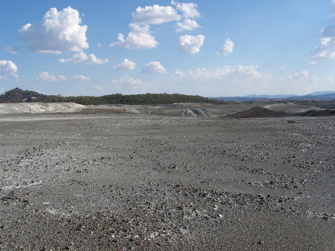
You may have also heard in the media that extra money has been allocated for Woodsreef in this years State budget. It is incorrect. The 4.5 million mentioned is simply the carry over from the year before.
The 2 photos below show why some people say the Woodsreef Tailings dump looks like a Moonscape.